
Happy New Year to our readers, although it didn’t start too well for those unfortunate enough to have experienced flood damage in the Storm Frank aftermath. With the current strong El Nino influencing global climatic events acting on top of climate change there was always a high probability that flooding would occur in the UK this winter. The Spey was fortunate to miss the worst of the recent extreme flows which delivered such devastation on east coast rivers such as the Dee and the Esks; our sympathies go to those affected.
Storm Frank deposited its heaviest rainfall on the east coast and with much of the Spey lying in a rain shadow to the west of the Cairngorms we were probably spared the heaviest precipitation. However there is another factor from which we benefit on the Spey, the value of which I am only now starting to fully appreciate.
A comparison of the hydrographs from the Park gauging station on the River Dee and the Aberlour station on the Spey shows significant differences (images downloaded from SEPA website 01/01/16).
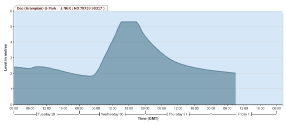
River Dee, Park gauging station hydrograph
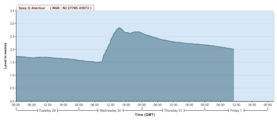
River Spey, Aberlour gauging station hydrograph
The peak flow in the Dee was much higher, peaking at over 5m, a record for the Park gauging station, and has a suspiciously flat top suggesting equipment or recording issues. The hydrograph for the Aberlour station on the Spey on the other hand peaked at about 2.8m, well below the highest level of 3.4m recorded in August 2014. River levels in both the Dee and Spey show the same steep rise but on the Dee it dropped equally quickly. Once the Spey level reaches this sort of height is drops slowly over a period of days producing a much shallower gradient on the downside of the graph. The reason for the major difference in the spate characteristics of the Dee and Spey is the ameliorating effect of the floodplains in the middle/upper reaches of the Spey catchment. Of course when lower tributaries such as the River A’an goes into spate there is very little floodplain storage available and it rises and falls quickly, as does the Spey downstream, although only in the absence of additional spate water from the upper catchment.
The impact of the storage available in the floodplains in the upper reaches is even more apparent from the Boat of Garten gauging station.
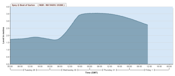
River Spey, Boat of Garten station. The broad peak and wide shoulder on the downslope of the hydrograph is clearly apparent.
As mentioned I am only now realising the value of the flood storage on the Spey. The value of these seemingly flat and uninteresting parts of the river were highlighted in the December 2015 issue of the Trout and Salmon when Eddie McCarthy, the highly respected and recently retired superindendent on the River Thurso mentioned that the “canal stretches take the surge out of the water”. Wise words indeed. As someone focussed on parr and smolt production the long, slow, flowing stretches in the upper Spey centred around Aviemore have been at times a source of frustration! These stretches don’t look like very productive parr habitat although they probably support more fish than we imagine. On the other hand the value of these areas, along with the associated floodplains, are immense in terms of the water storage capacity and their mitigating effect on peak flows. In the absence of these significant floodplains the Spey would experience 5 or 6m spates regularly with all the collateral damage that entails.
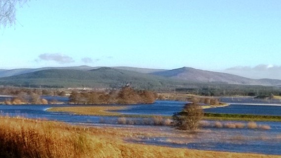
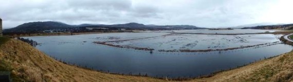
View of the floodplain downstream of Boat of Garten Dec 2015. The main river channel meanders from right to left through the centre of the photo, the river having overtopped the levees.
Another view from the same spot. The waters have spread out over almost half a mile of floodplain. Thankfully there are very few properties at risk on thses floodplains; the Spey has a rich history of floodplain inundation.
So we can be thankful that the Spey still has large floodplains, many rivers have lost theirs through development or improvement, but how intact are they? Actually not very is the answer. Insh Marshes is the best example but even it has been heavily modified with levees, drainage channels etc. I understand that the RSPB have commissioned a report on water management within the marshes although I have not yet seen it.
Insh marshes from Ruthven Castle. The A9 causeway bisects the marsh just upstream of this point and will undoubtedly influence it’s storage and drainage characteristics.
Further upstream at Laggan on the flats below Spey Dam the floodplain has been extensively modified with levees and drainage channels cut for agricultural improvement. Many of these modifications have been around for a long time; I have heard that napoleonic prisioners of war were used during the construction of the original levees. The lower Dulnain catchment downstream of Carrbridge would also at one time have been a vast marshy floodplain now converted to good agricultural land. There are extensive floodbanks along the river in the floodplain area below Boat of Garten which are often overtopped (pictured above); but does anyone understand the impact of these banks on flood storage capacity?
It strikes me that the floodplain restoration is a one of the quickest wins in terms of restoring the resiliance of the catchment in what looks like an increasingly wet future. There are a range of other measures that could, and should, be taken e.g. moorland drain blocking, reafforestation, peatland restoration, remeandering etc but many of these are long term issues or potentially small in impact magnitude compared to floodplain restoration.
Someone said yesterday that £1 spent in the uplands can be equivalant to £100 in the lowlands in terms of value for money towards flood mitigation. Floodplain restoration may impinge on livelihoods but surely it must be feasible to develop appropriate packages to ensure the viabilities of any businesses affected? However where is the leadership for such initiatives to come from? The current SEPA River Basin Management Plan appears to be distinctly unambitious in that regard with only one stretch of the Spey identified as suffering from morphological pressures relating to floodplain storage. Are we really content to see the WaterFramework Directive pass us by with only relatively minor improvements within the catchment?
With the current focus on flooding will it be “2016: the Year of the Floodplain”? Unfortunately that seems highly unlikely, what we really need is a Decade, or more likely, Century of the Floodplain, if the Spey, and many other rivers are going to continue to support the biodiversity and human life that they currently do.
The post 2016: The year of the floodplain? appeared first on Spey Fishery Board.
Spey Fishery Board
